Managing the landscape to control wildfires
Wildfires are not new occurrences, however climate change will cause them to be more and more frequent, even in areas previously not at high risk. So, how can we manage the landscape to limit the negative impacts of these fires? This expert article, written by EUROPARC Council Member João Cardoso de Melo, Marlene Marques and Débora Hemriques, details the experience of Sintra-Cascais Natural Park in Portugal.
Climate Change & Wildfires in Europe
Over the last decade there have been recurrent wildfires in Europe, with the 2021 wildfire season being the second-worst on record, according to the Advance EFFIS Report on Forest Fires in Europe, Middle East and North Africa (2021). The IPCC climate change projections (2022) predict an increase in temperature and more extended dry periods, expecting an increase in the frequency of droughts, heatwaves and other extreme weather events. Wildfires have been particularly harmful in Southern Europe (France, Greece, Italy, Portugal and Spain). Portugal has one of the highest forest fire risk rankings in Europe.
On October 6th, 2018, a wildfire burned 429.0 ha of the Sintra-Cascais Natural Park (SCNP) (about 3.0% of its total area) and had significant environmental, societal and landscape impacts, endangering people, and villages, affecting forestland and other natural areas. This event was a severe warning that wildfires, which occur annually in rural areas, can also happen in peri-urban areas, and threaten densely populated urban villages. Given this scenario, the combination of unmanaged areas and climate change pressures can promote even more severe, frequent, and large-scale wildfires in the future.
About Sintra-Cascais Natural Park
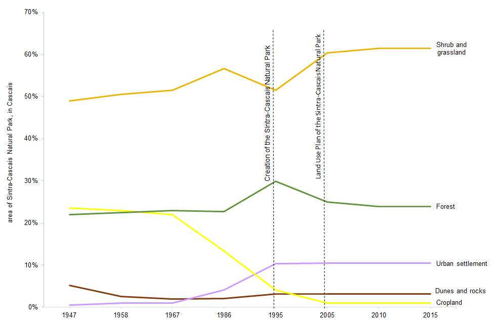
Area of Sintra Cascais Natural Park, click to enlarge
The SCNP, with a total area of 14,446.31 ha, is located within the municipalities of Sintra (11,174.75 ha) and Cascais (3,271.56 ha), two of the most densely populated counties in Portugal. It is classified as a
protected area by the Portuguese governmental Institute for Nature Conservation and Forests and a part of the Natura 2000 network for conservation of habitats and species under the Habitats Directive. It also includes the area classified by UNESCO as Sintra World Heritage Cultural Landscape, both by its cultural interest and natural beauty. The SCNP, characterized by diversified natural and semi-natural landscapes and a high environmental, historic, cultural and social heritage, is very popular for outdoor nature activities such as hiking, trekking, mountain biking and trail running.
Cascais Ambiente it’s a municipal company who provides technical support and manages the Cascais municipality southern SCNP area (SCNP-C). The company was tasked to implement a landscape management and conservation plan to restore the burnt area and implement actions to mitigate the risk of wildfires and adapt the landscape to climate change.
What needs to change?

Burnt area and vegetation in Sintra Cascais Natural Park, click to enlarge
We have studied the wildfires of the last 30 years, to analyse its recurrence and patterns in the landscape, the relation with human presence and land use, the type of wildfire progression, and the vegetation, meteorology, and topographic characteristics. The SCNP-C landscape has been shaped by agroforestry abandonment and a consequent increase of wildfire episodes. The annual burnt area averages around 80 ha and large wildfire, more than 400 ha, have an average recurrence of six years. The wildfires with the greatest burnt extension correspond mostly to fires dominated by the wind, some of them coinciding with the main wind corridors.
As the wildfires drivers are the meteorology, topography and vegetation, only the last one can be managed. Thus,
our goal is to introduce changes in the landscape and land use, not to avoid wildfires, but to contain their uncontrolled progression.
How can we use landscape management for wildfire prevention?
In SCNP-C, vegetation management has been implemented around main villages and roads. However, they are useless where wildfires are topographic. Thus, a new approach is needed to allow better suppression opportunities, but also promotes a sustainable management and the development of new dynamics to promote the economic and social development based on nature tourism and local farming.
To pursue this vision, the project is structured on three main pillars of action:
- Tackle and build landscape resilience to climate change impacts, particularly to wildfires, while preventing soil erosion, promoting the diversification of ecosystem services and ensuring biodiversity and ecological corridors by implementing sustainable agro-silvo-pastoral management models;
- Develop and demonstrate the sustainability and profitability of local economies based on agro-silvo-pastoral activities and ecotourism by fostering local production and promoting green jobs;
- Improve the knowledge base, develop awareness, and promote the engagement of stakeholders and the local community in climate change adaptation actions.
Concept and Methodology
The expected increase in global temperature will raise the frequency of drier periods leading to even more severe and large-scale wildfires, placing people, villages and biodiversity at risk. If the problem is not addressed, a scenario of severe and extensive wildfires could become even more frequent and endanger the sustainability and the communities of the SCNP-C.
Considering the particular characteristics of the SCNP-C area a set of management models were outlined according to local characteristics, mainly current vegetation and land use, biophysical attributes such as relief, climate variables (temperature, wind), soil type, hydrogeology, and historical wildfires (recurrence impacts). The implementation of these models will create a mosaic of different land-uses, generate vegetation discontinuities and undo the continuum that promotes extensive and severe wildfires, facilitate its suppression. It will also promote biodiversity and diversification of ecosystem services. These models will ensure natural and stable vegetation management, reducing human intervention and associated costs.
Find the exact management measures in the table here:
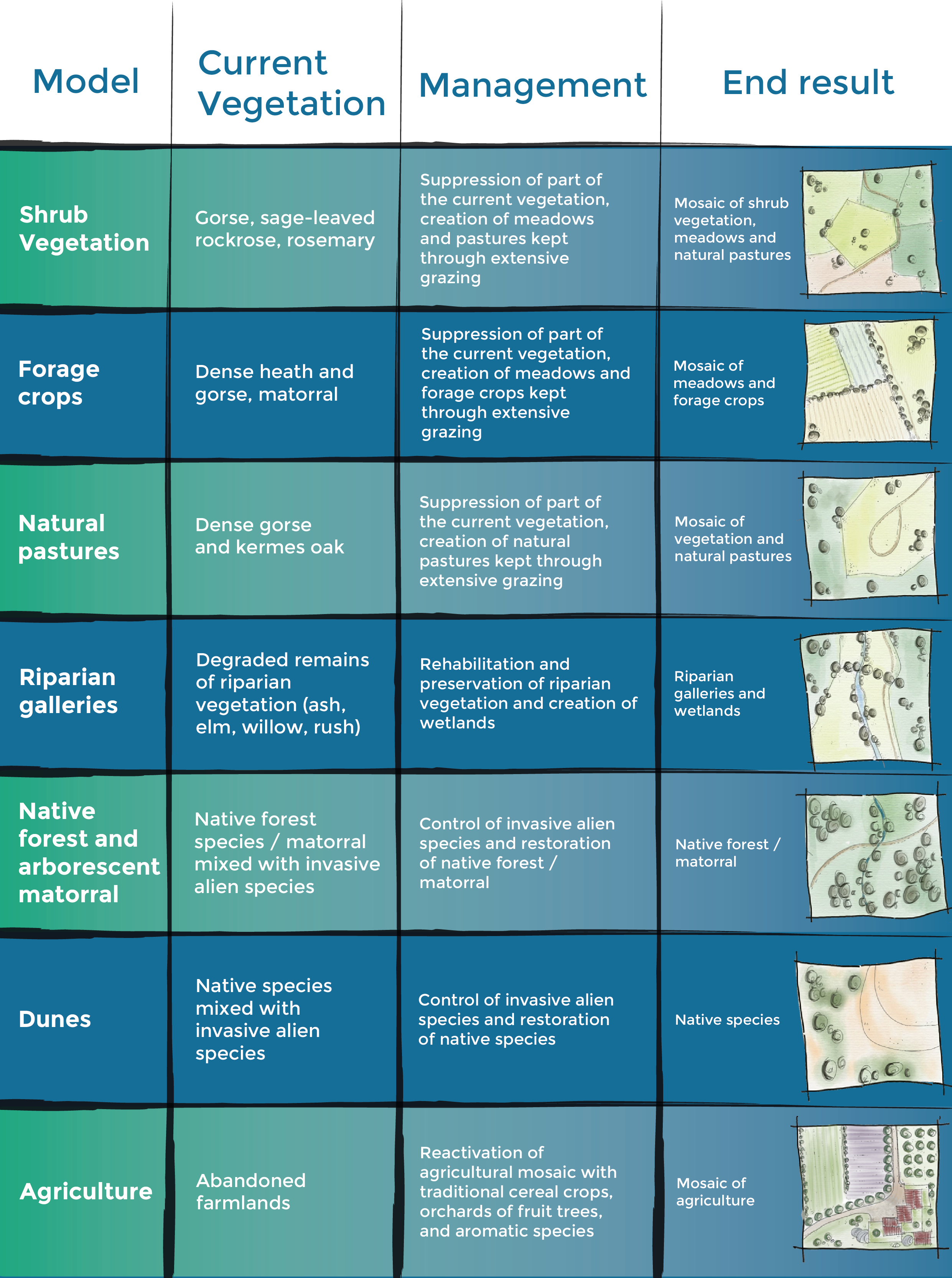
Click on the image to enlarge
EUROPARC thanks João Cardoso de Melo, Marlene Marques and Débora Hemriques for writing this article. João was also part of the 2022 edition of EUROPARC’s Siggen Seminar, which focussed on the role of Protected Areas in Nature Restoration. You can find the outcomes here.