EGNOS : a satellite-based system to support Protected Areas
In the age of digitalization, new tools are being developed. Some of them can be of great benefit to the work of Protected Areas by facilitating the collection of information, monitoring, and exchanges of good practices. One of these is the EGNOS initiative: the European Geostationary Navigation Overlay Service. They present a public and free tool that can help nature conservation.
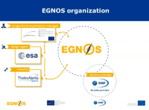
The programme exploitation manager is European Global navigation Satellite Systems Agency (GSA).
What is EGNOS?
The European Geostationary Navigation Overlay Service (EGNOS) is the public and free satellite-based augmentation system (SBAS) provided by the European GNSS Agency (GSA). EGNOS is a free public service provided by the European Commission that corrects the GPS data, reducing the error of the location measurements.
What are the benefits of this tool for Protected Areas?
Protected Areas can benefit from EGNOS for typical GPS field operations carried out in the framework of conservation of their ecosystems and management of their infrastructures. By providing more accurate positioning data, EGNOS allows to have better references of the Protected Areas’ elements in digital maps of geographic information systems (GIS). In this sense, EGNOS enhances the location and revisit of individual elements such as dens, lairs, nests, shrubs, trails, trees, dustbins, litter, picnic tables, signposts, etc. In addition, perimeters and areas, such as those of burned fields, ditches, groves, peat-lands, bodies of water, etc., can also be measured more accurately with EGNOS. In this way, EGNOS facilitates, to both field managers and operators, the performance of tasks related to the inventory, monitoring and maintenance of both natural and manmade items in Protected Areas. Concretely, it can help Park Managers for trail tracking, species monitoring and safety…
How does it work?
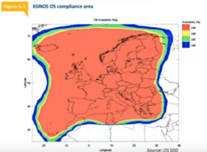
Area covered by EGNOS
EGNOS is available in almost all handheld GPS devices so no additional infrastructure (base station, radio link, mobile network coverage, etc.) is required. Protected Areas field employees only need to activate and configure EGNOS correctly in their equipment to automatically get more accurate positioning data at no cost. In this sense, it is essential to set the current active EGNOS satellites, whose PRN identifiers are provided in the EGNOS User Support Website. Some examples on how to configure EGNOS in mapping and GIS receivers can be found here.
For more detailed information of the proper configuration of EGNOS and its benefits for mapping and GIS applications, please take a look at this webinar recording. In order to have all the EGNOS up-to-date information with you, the EGNOS app is available for both Android and iOS. Finally, for any inquiry or issue, please do not hesitate to contact the EGNOS helpdesk by email: egnos-helpdesk@essp-sas.eu, phone: +34 911 236 555 or online form.